Monday, October 24th
Moonlight and Love Songs
It was still pitch dark when I stepped out of my room at half past six. Key West was quiet except for the occasional rooster announcing the coming of dawn. The moon’s thin waxing crescent was looming above. The deli at the corner of South and Simonton was already open, serving breakfast to a few early birds. I was walking towards the end of South Street, past a truck that had been running noisily all night to keep whatever it carried was frozen. Amidst the nearing holiday of All Hallows’ Eve it was everyone’s guess as to what exactly needed careful freezing.
The very end of South Street is dubbed Southernmost Point. A colourful cone twice a man’s size marks this very spot declaring it the southernmost point of the continental United States. The visitor, having brought a digital compass, wondered whether the military installation to the south-west was not part of the continental U.S. any more. Maybe it already belonged to Cuba, only ninety miles further south. Ever-trusty Wikipedia (at least on matters of a nit-picky nature) further details that there are even civilian spots further south, making it all a bit of a scam.
Back at the motel, I enjoyed my complimentary breakfast and thereafter retired poolside to scribe the notes of the previous day. Next to me, two Danish ladies where having a coffee and a smoke or two. Later, two German couples joined us, skyping home. Meanwhile, I used Jabber to relay my current position to everyone back in the office. “Breakfast next to the pool in Key West. Stop.”
Having succeeded in making everyone hate me, it was finally time to take off. At bright daylight, Key West was an altogether more pleasant affair. Its streets were lined by trees, a curious mixture of palms and more conventional variants. Hidden behind them were white wooden buildings in large gardens. The streets themselves were dominated by bicycles, scooters, and strange electrical mobiles that could be rented everywhere. Further on I stumbled across a handsome old town only a few blocks further from where I had turned around the night before. Here, the architecture was dominantly brick, either fully or interspersed with whitewashed walls. A large marked square was home to various booths selling all things touristy.
One recurrent theme was that of the Conch Republic. Contrary to popular believe, Key West is in fact the capital of this republic that seceded in 1982 from the United States. In that year, the US border patrol erected a road block at the entrance to the Keys searching vehicles for narcotics and illegal immigrants. The locals didn’t quite like that sort of treatment and decided that if the US erects a border, then they might as well just seceded and have their own nation. Subsequently, they declared war on the United States, but surrendered after just one minute, and pleaded for a billion dollars in foreign aid. The story has remained interesting ever since. The curious reader is referred to the Wikipedia article on the matter.
So far, the weather had been mixed with few clouds drifting above. It was quite windy this morning. But as I left town, more serious clouds were drifting in, looking a bit like there might be rain later. The navy was using the rest of the finer weather for some aerial games. Two fighter planes were toying with each other at quite low altitude over the island just east of Key West.
US highway 1, or Overseas Highway, today forms the main artery of transportation along the Keys. Right next to it run the remains of its predecessor, the Overseas Railway. Built starting 1910 it formed the first land transportation link to Key West. It didn’t last very long. In 1935, a mighty hurricane swept away most of it. Today, most of its bridges are dedicated as pedestrian walkways and are eagerly used by the local population as fishing bases.
I followed highway 1 east. A temporary road sign announced “state prisoners at work”. They didn’t quite look like a chain gang, but the concept sure is the same. And it shouldn’t be the only gang I would see during the day.
For quite some time, additional islands had been looming in the north. I was eager to have a look but there was no reasonable turn-off. Finally, after Ramrod Key a sign pointed to the left towards Big Torch Key. The road quickly turned into a calm country road. There was only small settlements in otherwise undisturbed nature. What looked like an old leave lying on the road turned out to be a big hairy spider and ran away. A bit further on, three vultures were sitting by the road eating god-knows-what. A mammal of indefinite nature, it looked like a deer but had a bushy white tail. was sitting one bend further. Above, big birds floated majestically through the sky.
The road ventured further north, making only ninety degree turns. Eventually, after one final left turn, it ended unceremoniously in a concrete barrier.
On the way back, five vultures were now sitting next to the road.
Across the channel lay Big Pine Key which featured two important things. First, the turn-off to No Name Key which I missed. Second, the Key Deer Habitat. For whatever reason, there seems to be deer on the Keys which, for more obvious reasons, is endangered. So this habitat was established, full featured with big black metal fences on both sides of the road and a plethora of warning signs. No wonder, then, that about halfway through I encountered a deer grazing by the road.
Further onwards, Bahia Honda Key, with its very own state park, and Ohio Key, with its very own trailer park, were leading towards the Seven Mile Bridge. The Florida Keys, you see, basically consist of three parts, prosaically named the Lower Keys, Middle Keys, and Upper Keys. The Lower Keys are relatively big, formed by many islands, whereas the Middle and Upper Keys are more or less just a string of islands along the road (or, of course, the other way round). The boundary between Lower and Middle Keys is marked by a relatively wide channel which is crossed by the Seven Mile Bridge, which actually is 6.8 miles long. By its side runs the older bridge of the former railroad, which makes a quick stop at Pigeon Key.
After the bridge followed Marathon, one of three bigger towns on the keys, so big that it stretched across several islands. The third big city, about thirty miles on was Key Largo. Here, I encountered the phenomenon of an active school zone (marked by a blinking light) and everyone dutifully going 20 mph for half a mile or so, when otherwise happily racing along fifteen miles over the limit.
After Key Largo, the highway turned left and, across several bridges, returned to the main land. A road signed warned of crossing crocodiles, but given the fences at both sides of the road and the big concrete barrier in the middle, this seemed somewhat unlikely.
So, was it worth traveling three hundred miles (or, actually, eight thousand) to see the Keys? Not really. The Overseas Highway is decidedly less spectacular than it would seem from imagination. For most part it is just another American highway with boring commercial buildings and big advertisement signs. There are little stretches that are quite impressive, the Seven Mile Bridge and some of the smaller keys where the road really just runs through the sea. But all in all, certainly not among the Best Roads of the World.
After returning to the main land, I had a decision to make. Would I want to visit the Everglades National Park? From the map, this would warrant a seventy mile detour on a there-and-back-again road. What I had seen of the Everglades so far looked decidedly boring: endless flat swamps with ever-repeating flora. Unless I joined on an airboat tour or went on a crocodile hunt, both not very likely, I couldn’t quite see why the detour would be worth it.
So instead I followed the tried and tested way to ignore tourist attractions and instead just drive on. Trying to avoid the busy outreaches of Miami and the toll-invested Florida Turnpike, I chose state route 997 straight north. I missed its exit due to the irritating American habit to only announce intersections by a small highway shield about three hundred feet before. At that point I was on the right lane and a police cruised to my left. When it had finally passed, the intersection had, too. Building a little loop through a petrol station, I finally arrived at the designated route.
Before entering into farmland, the road crossed downtown Homestead which looked like it had seen better days. Most buildings were in need of a new coat of paint at the very least. Even the inevitable palm trees lining the road had sad brown leaves. The only exception was the First Methodist Church, which was new and shiny and well-maintained.
Homestead: Rather poor, entire city could need a coat of paint. Even the palm trees are brown and look unhealthy. Except for the methodist church which is shiny and new.
After lots of farms and plant nurseries, another left turn took me onto Tamiami Trail, running across the width of Florida as an undisturbed ninety mile or so drive straight through the Everglades. Thanks to the Everglades Parkway about twenty miles north, traffic was light. The road first followed a freshwater canal with the odd settlement advertising airboat rides, before it entered Miccosukee Indian Reservation. Even so, it remained rather straight, the landscape to both sides very green but also very boring. After intersecting with another road leading to another outlet of the Everglades National Park, the road finally developed some curves and became a bit more interesting. The landscape was first very park-like. A small stretch of immaculately cut lawn to both sides of the road, then various trees; some water bodies. Later, it entered into a proper swamp with water and reed. A sign quite unexpectedly announced “Panthers crossing”, right after which followed a small rest-stop.
This here was the Big Cyprus National Reserve. It featured the Oasis Visitor Center which in turn had a boardwalk through the swamp. Sounded quite exciting. I drove on.
Eventually, we returned to civilization. And what a civilization it was. Gated communities with gigantic entrance monuments, much like the one featured in the opening credits of first seasons of Weeds. Lots of lawn everywhere. Big, white colonial houses, nay, palaces. The odd lake with a fountain. If you are looking for the other one per-cent, I suggest starting here.
The highway grew into a six-lane road and became rather busy. We had arrived in Naples. I turned off the highway and drove into downtown, out of the realities of this world and into a children’s picture book. Large, colonial houses in their gigantic grounds, trees everywhere. The streets spotless clean. Everything new and expensive. The commercial buildings in the Fifth avenue shopping area were oversized colonial buildings instead of the normal concrete blobs.
I drove back to the highway along the coast and through more otherworldly gardens, not quite believing all of is after the aimless beggars of Miami.
But even here the economy is badly hit. A stopped at a mall in North Naples. Most of its shops were empty, the windows boarded shut. And its book store, yet again, was sub-par.
Further on, the town of Bonita Springs at first looked like the place where the poor people live. While the lawn on the road’s median was still properly maintained, the houses looked shabbier. The closer you came to the sea, however, the posher it became. Still, it looked more real than Naples. The still gigantic villas more human and the whole arrangement of buildings, trees, and parks refreshingly messy.
Next up, the endless town of Fort Myers Beach. Funny how one can grow tired of a beach resort town when it goes on and on for half an hour or so.
Finally, I arrived at the highway towards Sanibel Island. It crosses the Sanibel Causeway by way of a toll bridge, where I committed a bit of a faux-pass that may turn out to be expensive. When renting the car, it was pointed out that it was equipped with an electronic toll device and that I could just drive through the e-toll lanes. Similarly, there were two large stickers on the windshield saying the same: just drive through. The actual device was hidden behind the rear-view mirror and featured sticker noting that you had to enable it by way of a lever. Which I didn’t realize until it was too late.
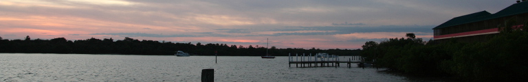
Quite angry with myself or possibly Avis, I drove across Sanibel island more or less blindly. My destination was the next island, Captiva, where I planned to spend the night. After looking through town, I decided to stay at the ‘Tween Waters Inn. Yes, a resort, but of the more distinguished variety. I settled into my room overlooking the Gulf of Mexico. Sunset was but half an hour away and promised to be good. Thereafter, I retired into Old Captiva House for an excellent seafood dinner. The restaurant was described as the only Fine Dining establishment in Captiva and fine it was. It even had a piano player offering variations on Time Goes By and the like. Certainly beats Karaoke.
When I left the restaurant, it was dark again, a clear night, the moon not out yet. I went down to the beach and lay there for a while, gazing at the Milky Way above me, entirely at ease with the world.