Wednesday, October 26th
West by North-west
Apart from being really good looking, the Mustang also had a nice feature allowing to plug the iPhone into the stereo. It was named “Sync powered by Microsoft” and the latter showed. It was always a struggle to get it to actually sync. By now, I had figured out the dance. You had to plug in the phone before turning on the ignition. Then there was a good chance it picked it up. If it failed, turn off the ignition, take out the keys, open the door and start over again. How did this joke go about what happened if Microsoft built cars?
This morning, there wasn’t many options other than continuing further north-west. The highway was divided with hardly any traffic and quite nice to drive along. Towns were spaced about a dozen miles apart, most of them very small, just a few buildings and a school. Not much to remember except a large place that sold mobile homes just north of Chiefland.
Mobile homes, not to be confused with the gigantic buses that go for caravans here and are called RVs as in recreational vehicle, are in fact buildings on wheels. Maybe twenty by a hundred feet, they are just small enough to be loaded onto a truck and shipped to another place. They also look rather bleak, much like a little gray box. The reason to have them isn’t so much the mobility as the lower cost of living. Normally, they live in a thing called trailer park which you find all over the country, for instance just north of the aforementioned sales place.
After Shamrock, the opportunity arose for a little detour along small country roads which I eagerly took advantage of. The road went to the community of Jena and then onwards to Steinhatchee (Gesundheit!) where it dead-ended by the river. Tracking back a bit, I managed to find the river bridge and the rest of the village. Given that it lay by the river and this is Florida, its main component was boats, although there was plenty of lovely homes in the shadows of mighty trees, too.
After Steinhatchee, the road became extremely quiet. Which proved the immigration officer wrong who claimed that I would hate Florida if I was looking for undisturbed driving. As always, you just have to know where to look.
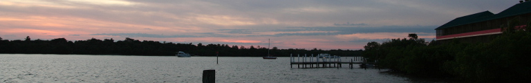
In Keaton Beach, another small, laid back community by the Gulf, all buildings were erected on stilts. As I would see during the day, this is a very common building style along the Gulf coast.
Back on the main highway, I arrived in and crossed through the next bigger town of Perry. A book store by the side of the road announced that they had “Florida books, bibles, and more.”
After Perry, the landscape became rather rainforest-y. Large, extremely green trees and thick, determined undergrowth. The Aucilla river looked suspiciously like Tarzan might swing across the road on a liana.
The road also slowly returned to the Gulf coast. But it didn’t quite so I turned off and drove into the village of St. Marks. Also not quite down by the Gulf shores, it’s center consisted of an intersection by the river with a grocery store, a cantina and a boat store. It also featured a refinery of sorts, a self storage, a truck garage, and a gun store. A bit further, by the river, was St Marks River Park. Predominantly a place to launch your boat, its parking lot was full of trucks with boat trailers. There were a few benches by the river and a large wooden pavilion. A sign declared “alligators and snakes present,” but mostly there was lots of squirrels and noisy birds. All in all a lovely place for lunch.
After that I became a little tired, so a few miles on, after crossing the confluence of the Ochlockonee river on a giant bridge, I stopped by the river and had a little nap.
The road finally returned to the gulf and from now on ran alongside its shores. This allowed for many vacation opportunities and hence the wilderness was over. Whenever there was a river, there was a larger community such as Carrabelle by the Carrabelle river. These tended to have larger apartment buildings and apple anchor space for pleasure boats and the odd fisherman. The road always crossed these bays directly on long bridges without bothering to go a bit inland to save on bridge span. The flora had changed to pine forests.
At the entrance to Eastpoint there most have been more fisherman as it smelled suspiciously of their produce. In Eastpoint, a road turned off towards the St. George Island which sounded interesting enough to go and have a look. The road crossed Apalachiola Bay by way of a very long bridge. For once, this bridge wasn’t painted turquoise but it still had an older sibling running alongside it. This older bridge was actually two bridges with a long dam in the middle. The new bridge is four miles long and was opened only in 2004.
St. George Island was really just a glorified sand dune. It had a fine pine trees on its northern side and a wide sandy strip to the south. The strip was plotted up and had now houses cluttered all over, ranging from the modest to the embarrassingly expensive. Judging from the amount of houses with a car out front on this Wednesday afternoon, about two-thirds were permanent homes.
The only land not privately owned on the whole island was a state park at the eastern end. However, it charged six dollars entrance fee and I couldn’t quite find a reason to pay that. Instead, I returned to the main land and onwards west, which involved crossing yet another bay on yet another bridge.
The city of Port St. Joe styles itself “Florida’s Constitutional City”. This is because the first constitutional convention for the new state of Florida happened in the town of St. Joseph, now gone and part of Port St. Joe. Which raises an interesting point. Normally, when thinking of Florida, we think of the Florida peninsula. As it happens, though, the state also has this long stretch of land alongside the Gulf, known as the Florida Panhandle. And this is where the modern state of Florida started, Tallahassee, twenty miles north, being its first capital.
West of Port St. Joe, the vacation parts of the Emerald Coast, as this area is also know as, started in earnest. The coast became an endless village of second home, apartment buildings, the odd business strip. This was only interrupted by the Tyndall Air Force Base outside Panama City.
Not to be confused with that other Panama City and named merely after it because it lies on a straight line from Chicago to Panama City (what sort of reason is that?), Panama City, Florida, is an industrial and port town. It is, however, trumped by Panama City Beach, otherwise known as “Spring Break Capital of the World” and as such to be avoided desperately. It runs for ten miles along the gulf shores in the form of highrise resort buildings and similar symbols of modern mass tourism.
It would actually have made a good location for an overnight stop, but I much rather drove on for another hour or so and made Destin my, well, destination for the day. Unfortunately, Destin turned out to be a resort town as well. In fact, it is much more popular than Panama City Beach with 80% of visitors coming here. It is highrise towers, too and even has an old-fashioned amusement park. However, it also has the Holiday Inn as a hotel in a round tower. Or, as one of my obscure rules of the road says: If there is a hotel in a round seventies’ building, you have to stay there.