Friday, June 13th
The Last Hurrah
The plan for the day was easy enough: Get within easy reach of Chicago’s O’Hare airport. This, then, was my last driving day.
I left the crowded area of the twin cities of Cedar Falls and Waterloo by way of quick motorways before some twisting and turning finally brought me onto a county road heading due east.
I crossed the unspellable Wapsipinicon River at Troy Mills, a quiet collection of homes by the shores of yet another lazy wide and narrow river.
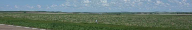
Beyond the mostly flat landscape of fields, the odd tree grove and plenty of farm yards continued. A lonely church and cemetery appeared by the road. The church was red and build from stone, hinting that at it being a Catholic church. As this was a few miles outside of a slightly larger town named Monticello, such alignment wasn’t entirely unthinkable—and indeed confirmed by later research.
The church started an area of rather heavy settlement on both sides of the roads. This, it seemed, were the suburbs of Monticello. Its standard one street brick shop centre was buzzing with life, too.
As my county road had ended in Monticello, I continued south for a bit before turning onto a new eastbound road at Scotts Grove, a small collection of wooden houses. It started to get seriously hilly again.
The road had to cross the Maquoketa River and did so on a long and narrow bridge. At little both was standing by it, labelled USGS. Most bridges over serious rivers had such a booth or at least some equipment. USGS is the US Geological Survey. Perhaps they were measuring water depths.
This new road also served as the Grant Wood Scenic Byway, featuring the window of the American Gothic House as its logo.
The houses of Andrew City, a confusing intersection of many county roads, were gathered around the water tower atop a hill. Next to the tower were a school, a ballpark, and the cemetery. All you need for the circle of life.
Then down into a very green valley. The road followed it for a while before deciding that this wasn’t its thing. It broke through the valley walls by way of a rather grand cut that brought out the rock layers. Back up was fields and farms and Springbrook, special in that its country store was in a yellow sandstone building. The village, too, was on top of a hill. This meant that the homes couldn’t be hidden away in parks but stood proud atop the hill line.
The end of the road let to a little turn north before reaching the valley of the Mississippi River. While there was water to be seen, this wasn’t the great river, however, but the flooded plains of the valley. The road, I had rejoined the Great River Road, led south along the outer valley for a while before turning inland a little.
It crossed through a valley rich in trees, forming an alley of overarching leafs, then climbed atop a bare hill, before falling down into a valley again. It kept repeating the process for more time than should technically have been possible from the distance given on the map. Eventually, it came up upon an intersection where a road promised to take me across the river.
First, though, it crossed a lake on a damn with a little island halfway along whit a parking lot and trees. At the end of the dam was Sabula, Iowa’s Island City. It was indeed on an island in the flooded valley of the Mississippi, with the river bounding the city to the east. There was a little park there, ideal for a short stop.
But it wasn’t quite time to cross the river just yet. First a dam led north for a few miles in search of a narrow enough point for a crossing. It found it and thus I finally crossed the Mississippi one final time on a scarily narrow blue metal bridge. By now the river had turned from a narrow creek into the mighty stream it was known as.
The bridge also took me into Illinois. The first town was Savannah, just across from Sabula on the other side. It was quite a bit bigger, though.
I continued eastward on a road that featured passing lanes, always a sign of too much traffic. Indeed, there was plenty. The landscape, too, was rather more busy than it had been in north-east Iowa. The first few miles were hilly again and littered with homes, then followed a return to the slow, long hills with farms. Around here, the villages didn’t have the grain elevators but each farm had its own. There were hundreds of little concrete towers dotting the landscape all the way to the horizon.
I turned off the main highway onto what looked like minor roads on the map in hope to find them more calm. A little north, then east again onto a road that should take me all the way to the doorsteps of the hotel I had chosen for the night. What seemed like the homestretch, however, was still a good two hour’s driving. And the road didn’t really calm down at all. Northern Illinois was one hell of a busy area.
There were plenty of more or less identical villages along the road, too. Byron was the larger one. It may or may not have been named for a certain poet, but it certainly wasn’t very poetic, apart, perhaps, from the crossing of the Rock River which featured a lush little park. Byron also is home of a nuclear power plant which I had been seeing some time ago but had forgotten about by now.
The road followed Rock River through trees for a little bit but decides that it was too busy for winding along and returned to flat fields. By way of Davis Junction, the water tower hinting at a railway history by having a locomotive painted to it, and various other villages it reached Genoa. A carnival was in town abusing main street for its festivities requiring a detour beyond the railway tracks.
At Hampshire, a few miles on, I finally reached the outskirts of Chicago: its first suburbian developments. These were collection of identical looking houses, this far out all relatively new, gathered into small communities. Little boxes, though not by a hillside (for lack of one) and, by the looks of it, also not made of ticky tacky any more.
A sign by the now insanely busy road suggests forty five miles to Chicago. Not far is the Interstate, around here a toll road, making the commute not only long but also extra costly.
Now just through West Dundee, which has a nice little centre on box sides of the Fox River bridge, and I am in Hoffman Estates, which I may have chosen as my destination because of the name. Founded only in 1959 as one of them suburbia villages, it has since grown into a city of fifty thousand people. The airport is only a few miles away.
And thus it is time to clean out the car, finish these lines, and fly away.