Two
North Carolina
Somehow I have left the big clouds behind and during the last miles the sun has come out. Safely across the state line, I have immediately turned off the main highway with the intent to venture south-west further into North Carolina.
Quickly, the endless settlement ends and there is fields and patches of forest. The village of Francisco (sans San) isn’t much more than a fire department, a school, and a church. On the other side of the street, on a bare hill, stands a man with a bare chest and no immediate purpose.
It has almost turned five, so I decide to amend my plan. About thirty miles to the south lies the urban sprawl formed by the cities of Greensboro and Winston-Salem which I’d like to avoid. Not quite as far is the city of King, reasonably close to a motorway and given in slightly increased type on the map. I turn left at the next occasion and head there.
I get lost a bit searching for the centre but eventually have to face the truth that expectations have been greatly exaggerated. King is a rather small affair in lack of motels of any kind.
Still not wanting to venture further south, I turn north instead and take the motorway to Mount Airy back at the border to Virginia. I quickly find a motel which, conveniently, has a restaurant in walking distance.
You know you have ventured far into the South when in the breakfast room CNN is replaced by Fox News. So, after receiving the balanced information about whose fault the government shutdown really is, I head out, picking up my generally south-western orientation.
The area is heavily settled again. The rather narrow highway is winding through hills with house after house. Still, the speed limit is 55. Presumably, this is considered safe since there is bound to be no pedestrians whatsoever.
The houses take a short break and make room for two gigantic villas. Like twins they are standing side by side a bit set back off the road to the right: giant red palaces in an otherwise empty field. Instead of a fence, their fiefdom is marked by solid fence posts.
Having succeeded in baffling the traveller, the regular program of small houses returns before the road dives into a hilariously green valley. There is a river there and a railway line, but the most prominent feature is ivy. It is everywhere: in the trees, covering buildings, even signs. We must be back in farmland, though, since there is the odd ivy-covered mill each with its pair of large silos.
The town of Elkin features what I first thought to be a prison but turns out to be a factory of sorts. A giant thoroughly fenced in area with a flat grey concrete slab. It is followed by more factories and a tiny town centre up the side of the valley.
The factory themed morning continues in Roaring River with the Roaring River Milling Corp. There is hardly anything else but a church and a café. Still the roads are getting more and more busy. It appears that everyone is heading for North Wilkesboro, starting out with, you guessed it, more factories.
Eventually, it develops have a rather nice centre of red-brick shoe boxes and lots of trees. It, too, has been arranged up the side of a valley. The road goes up the hill, showing off all there is to see and then turns around down again. That may explain why everyone had turned off left at some point. At the topmost point looms a pair of churches on opposite sides of the road, one Methodist and one Baptist, an arrangement that seems common around here.
The road swings across the river, its valley having been used for a shopping centre, and arrives at Wilkesboro, seemingly the smaller of the two. There is more red shoe boxes and church pairs. There is also the Wilkes Heritage Museum in a large white building set back from the road in a small park, announcing a zombie walk for October 19th. Too bad I’ll miss that.
The town concludes with the Tyson Processing Plant, preparing ready-made meals, as I coincidentally had ‘learned’ last night on TV.
The road is still busy but I manage to turn off again and things become quite. There is less cars but there is also less houses by the side of the road. Every now and then, there even is a small patch of trees. To give thanks, there is a Jesus Life Worship Center.
The next town is Lenoir. The plan was to turn north before entering it properly, though, and only see the commercial outskirts. Things start out well enough, I spot the sign for the highway I intend to take. But suddenly I find myself on a road leading south-east according to the sun. I swing around, trying again, but eventually give up and settle for a route heading south-west and taking me quickly to Morganton.
Bewilderingly, the same thing happens there again. I spot the sign for the my highway to the north-west only to find myself at the southern fringes of town. And surely I wasn’t distracted because there isn’t really all that much to see.
From what little detail the map has, I guess a strategy and eventually indeed find my road. I celebrate that with a quick lunch break. It also doubles as a toilette break, even though, at the common soda serving sizes, that is a strategy to backfire quickly.
After town the road becomes empty and curvy, there is the odd RV about. Clearly, I am heading into the right direction. There is a Danial Boone Campground, reminding me that I should probably read up on the man for all I know is his headgear.
The road becomes ever so more curvy. Some of the really tight bends appear a little unnecessary, but there is plenty of sections with an extra lane, so I can pass the curve-fearing Americans and have a bit of fun. After ten miles of mad climbing, the top is marked well with a church.
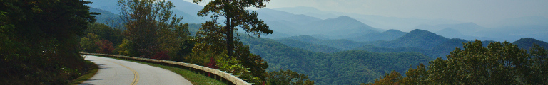
After consulting with my map, I decide to leave the north heading road and turn west. At Linville Falls, I dive under the Blue Ridge Parkway yet again. There is some cabins about, but otherwise everything is quite mountain forests. The Linville Falls Winery is a bit of a surprise then, covering a hill flank with actual grape plants.
Through the villages of Crossnore, spread all over a lush bowl, and Linwill, at a lake by the road and featuring a solar farm, across what a sign describes as the ‘Eastern Continental Divide,’ before I realize that I am lost again. I must have missed my turn off and am now heading north again.
This new route takes me out of North Carolina and into Tennessee a little sooner, which is probably a good thing or I’d get lost even more.