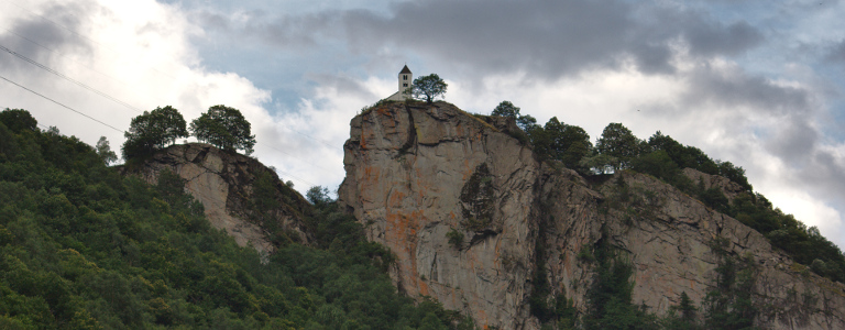
When you travel southbound across the Gotthard Pass and look out of the window a couple of minutes after the train passes the station of Faido, you will see a small church placed at the top of a huge cliff, maybe three hundred metres up.
I had passed this sight many a time and one day decided to have a closer look. The next day after work, I picked up the Renault convertible the local car sharing company has available for such occasions, and took off. The fasted way would be the autostrada from Lugano to Faido, but somehow this sounds decidedly un-convertible. Instead, I passed by the motorway entrance only to stop a while later and order the car to wind back its hard top by the push of a button.
This was my first trip ever in a convertible. As with all things you know only from movies and television, there is risk that you build up an expectation that is all but impossible to fulfil. But not so the convertible, which is exactly as much fun as TV promises. It is the perfect combination of the freedom and openness of a motorcycle and the comfort and protection of a car.
The wind in my hair wasn’t caused by speed, though, as I slowly crept through the afternoon rush-hour. Which was pretty bad. The people of Ticino combine the Swiss enthusiasm for commuting with the Italian enthusiasm for the motor car. And chaos. There are days when central Lugano, thanks to its one-way street layout and careless blocking of intersections, is quite literally gridlocked. Today came close, but I managed to escape the hot madness.
Half an hour down the road I finally reached Bellinzona, which wasn’t much less crowded either. Its traffic lights were of an especially mean persuasion. When you approached them, they turned red. Once you had come to a stop, they turn green again, without any cross-traffic ever having seen green at all. The result wasn’t the probably intended calming of traffic, but a lot of noise as cars stopped and accelerated all the time.
Beyond Bellinzona and even more so after Biasca, where the road entered into Valle Leventina, traffic finally calmed down. Now there was only local traffic left: the occasional tractor or a Japanese micro-van which seems to double as a pick-up truck in these parts of the world. The through-traffic across the Gotthard Pass used the parallel motorway.
The valley was mostly wide and level, leaving enough space for villages and farming. It was formed by the river Ticino, which also lend its name to the canton. But to reach the valley’s end at the town of Airolo two imposing steps have to be mastered where the valley becomes small and steep. These are known as Biaschina and Piottino.
The motorway, a child of the age of concrete, resorted to a sequence of daring bridges and tunnels. The engineers of the railway, working a hundred years earlier, had to find a more ingenious approach. The line needed to be stretched so that it could make the necessary altitude using the limited gradient chosen for safe and efficient train operations. The usual approach, going up a side valley for a while before returning, thus increasing the distance by a few miles, couldn’t be used, because there were no side valleys.
Instead, a sequence of circular tunnels was dug into the mountain sides, each coming out roughly where it entered the mountain only a couple of metres further up. The result was the rather spectacular layout in the Biaschina, where the railway line appears three times on different levels with the bridge of the motorway forming a forth. Similar arrangements exist at Piottino and north of the pass at Wassen where the train traveller can see the church of Wassen three times from different angles.
The old road, meanwhile, had to do with the old trick of serpentining up, increasing the fun for the driver unless you got stuck behind some scared caravan carefully sneaking around the bends. Right after the switchbacks of Biaschina, at the entrance to the town of Lavorgo, the road up to Calonico, the village owning the church, forked off in a sharp one hundred and eighty degree turn and immediately started to climb up the hill in a stunning sequence of switchbacks that just wouldn’t end. No wonder, really, since the road had to gain three hundred metres of altitude on a mountain side that was practically a vertical wall.
After some twisting and turning, I wound up behind the postal bus doing its afternoon round. But since the bus drivers are a surprisingly friendly breed, the bus stopped at the first opportunity to let me pass.
Eventually, I arrived at Calonico and parked the car. The village consisted of some ten houses, a piazza with a fountain, and ample nature. A paved path led from the village to its church and via some distant farm houses back to the village. The church itself sat on the very top of the cliff, a small white chapel, really, surrounded by its graveyard. It was first built in the fourteenth century and dedicated to San Martino. The bell tower was still original but the small main structure had been rebuilt sometime in the seventeenth century.
From the top of the cliff, I enjoyed a wonderful birds-eye view over the Leventina valley, all the way up to Faido. Below were the river, the railway, the motorway, the normal road, and not much else. Unfortunately, this onslaught of mobility made the valley extremely noisy. What looked like a romantic and pleasantly backwards part of the world, in fact struggled quite badly with the realities of modern life.
Another drawback of a valley going north to south and having steep sides was that the sun was setting rather early. Up here, the air cooled quickly. In a convertible, the difference between 24 degrees centigrade and 21 turns nice, warm air into a bit of a chill. Time to go back home.
Except that back in Bellinzona I couldn’t quite resist temptation and turned off the main road into Valle Marobbia. It was my hope that there would be another road connecting the two parts of Ticino. But they are named Sopraceneri and Sottoceneri—“above Ceneri” and “below Ceneri”—for a reason. Monte Ceneri is the pass in the mountain range between those two parts. One contains the cities of Bellinzona and Locarno with the river Ticino and being above Ceneri on the map, despite actually being lower in altitude with Locarno the lowest place in all of Switzerland. The other, with Lugano and the valley leading towards Como, below Ceneri.
The road across Monte Ceneri (or the railway or motorway tunnel below it) indeed were the only connection between Bellinzona and Lugano, no matter how hard you tried. But Valle Marobbia was quite spectacular in itself. Like most side roads in Ticino, the road required lots of turns to find its way along the steep walls of the valley to venture to a series of small villages.
By now the temperature had dropped below twenty. I gave in and returned towards home. I could have closed the roof but that felt somewhat wrong. Instead, I drove up Monte Ceneri and down the valley of the river Vedeggio where it warmed up a bit again and finally back to Lugano, rewarding myself with a fine glass of Ticino Merlot for a nice little after-work adventure.