Wednesday, June 4th
Wherein the Great Plains Begin
The greatest wonder of travel is that you find beauty where you least expect it. I had chosen Bemidji mostly because of its somewhat out-of-place sounding name. Upon approach, it looked very promising, full of trees and parks. I found a hotel right by the south shore of Lake Bemidji and got a room with a view of the lake. The hotel even featured a private sand beach from which you could enjoy the sunset over the city’s small, leafy skyline: only a few tiny towers poked out of the trees.
The next morning, as I headed out for a bit of exploring, I discovered that the centre indeed was essentially a park by the lake shore. It featured the visitor centre and a pair of large statues of Paul Bunyan and his partner Babe the Blue Ox (a similar statue in Brainerd can be seen in the aforementioned classic film). A small, more traditional centre follows a few blocks off the lake shore but quickly the scene becomes residential houses in rather large plots again.
Besides petrol, I had another errand this morning: mosquito repellent. Things had clearly gotten out of hand and it was time to take some measures. Little surprise that the stuff is readily available in drug stores, even if you have to ask where they hide it.
Shopping done, I ventured out of town along the Great River Road again. However, I must have dosed off a little and missed a turn. After quite some time, haven gotten slightly suspecting given that there was no more highway shields for the road, I found myself on the great westbound highway. Turns out it is helpful to have a map, anyway, which quickly brought me back on track.
I crossed the Mississippi a few more times, having shrunk now to a narrow stream, perhaps six feet wide. Eventually, I came up against an intersection. Beyond was a wooden church, St. Catherine’s, and a sign indicating the start of Itasca State Park.
The park entrance was self-service: You stopped by a hut which provided forms including an envelope. Fill out the form, put five bucks (or twenty five for a yearly pass) into the envelope, rip off the receipt to place in your wind shield: done.
The reason for my visit to the park was simple: It contained the official Mississippi headwater. Naturally, there is much disagreement about the actual source of the Mississippi (and, as with all things of a finicky nature, you can read all about it in Wikipedia), but for the time being it had been decreed to be at the outflow of Lake Itasca.
Not far from that outflow was a parking lot and a visitor centre in a large log cabin. A path started at the centre, eight hundred feet through forest and you arrived where the mighty Mississippi river began its two thousand mile long journey to the Gulf of Mexico. The site was marked by a pole, the exact place indicated by a row of stones in the water. Originally, it had been a bit of swamp which outraged some people so they fixed it in the 1930s with wood and concrete. Now there was a damn and a clear canal for the river and a sign saying that they would do things differently today.
For the return trip to the centre a board walk along the river and through the ex-swamp was provided, a lovely stroll that seemed to prove the great success of the bug repellent.
Something called the Wilderness Drive provided a trip through the northern parts of the park, essentially a loop around Lake Itasca. I switched into Park Driving Mode (ie., music off and windows down) and drove through the wilderness. First, it was spring green deciduous trees but later changed into pine forest for a while.
A sign indicated a half-mile trail to a small lake and I decided it was time for another little stroll. I didn’t get all that far, though. Repellent or not, the mosquitoes were fantastically annoying. I also had failed to properly apply the repellent to all exposed skin and soon enough the little buggers found the unprotected bits. Back to the car. Quickly.
Soon yet another sign suggested a visit to Itasca’s largest white pine tree, only 250 feet to walk, but I had enough and kept driving.
The park was quite calm and, from the protection of your car, lovely. Highly recommended.
I left it through its south entrance before turning west again along a road that promised forty miles of wilderness before reaching the next settlement. There was a series of lakes, Bad Medicine Lake, Elbow Lake, Tulaby Lake, McCraney Lake, each with a cluster of cottages and a boat launch.
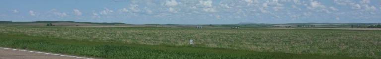
Eventually, the forests became patchy, the road went downhill before the landscape became flat and open. I had reached the Great Plains.
Waubun, that next settlement and first in the plains, consisted mainly of a large school by the north-south highway, a sports bar, and grain elevators by the railway line, north-south, too. I kept heading west, though, finally rid of bends and curves, only occasionally stopping for a crossing road with a tiny village attached to it. Syre first, which featured Al’s Garage, Borup later, which featured hardly anything at all.
The strange thing about prairie driving is that even though it sounds immensely boring—going straight through a flat landscape—it really isn’t. Driving through woods is a whole lot more boring than this. Perhaps it is the endless view in each direction that gives your brain something to work with. I was quite a lot more happy to be back in the prairies than I should haven been.
One more intersection by a village called Perley and a bridge across the Red River meant that I had entered the next state, North Dakota. The road did a ninety degree turn left and then right again to align with this state’s geography and went back to calmly heading west.
At this point, the map switched to a smaller scale indicating that I had reached the western half of the US. This also meant that I had to retrain my eye for the new scale and it quickly became apparent that I wouldn’t make my intended destination, Devils Lake, before seven or so. This morning I had also determined that I was advancing to quickly, so I re-aimed for either Valley City or Jamestown.
For the last hour or so I had been driving towards rather dark clouds, but now there was sunshine again. It seemed that the clouds were brewing over Red River and staying put there.
There is little to report: the odd intersection, perhaps with a railway line or an Interstate motorway, the giant brown complex of a school by a tree grove formed by a stream, more intersections, more railway lines and eventually the end of the road. I turned north for a bit to find the next road west.
Here, the really flat bit ended for now. The landscape became hilly, it even formed a long ridge outlined by a series of wind turbines running as far as the horizon both to the north and south. The road turned again before descending into the valley of the Sheyenne River. A damn erected in the 1950s has turned the river into Lake Ashtabula. Where the road crosses it lies Sibley, a bunch of houses and trees and a euphemistically named City Park by the river.
Turning off onto a southbound road after I climbed out of the valley, I had to cross the lake yet again. This time, there was no settlement but two recreational areas on either side of the crossing and a restaurant in between.
Climbing out yet again, the Sheyenne River had to be crossed a third time right outside Valley City. I came over a hilltop and to an quite astonishing sight. High above the valley, the railway line had to cross it by way of a long girder bridge looking very Western. Below it, a large grey grain elevator completed the scene.
Valley City was yet another dusty prairie town. It had a little one block park at its heart, where a fighter jet and a few guns where on display. The city was over as quickly as it started, the road leading directly and inevitably onto the Interstate. I considered turning around for a moment but then shrugged and raced the thirty or so miles to Jamestown instead. Along the way, a sign pointed out the Continental Divide at an elevation of 1,490 feet.
I truly had arrived in the West.