Monday, June 9th
Dead Presidents
I headed out of Sturgis realizing that I hadn’t even had looked at it. The Internet had mentioned that there would be a large biker fest in early August and, judging by the hotel parking lot, it was indeed rather popular with bikers. But town centre was the wrong way and instead I was aiming west again, back towards Deadwood.
Yesterdays rain and clouds had entirely disappeared. That indeed had been the plan behind my detour towards Pierre. I could now enjoy the Black Hills and its assorted attraction in brilliant sunshine.
Outside Sturgis, the road entered into a steep valley for a moment before climbing into more generous valleys. At the entrance to Deadwood there was a rodeo arena which I hadn’t noticed the day before. I bypassed the centre this time and headed out of town again where gold panning was on offer, a mandatory feature on any TV production about any area that even remotely had anything to do with gold.
The road I had chosen seemed to bypass the neighbouring town of Lead. It only briefly touched its westernmost parts, comprised of an ugly brown brick building. Points if you guessed school. Then out again and down into another steep river valley. A sign announced winter sports or possibly the opportunity for some given the right season. The valley itself was quite busy despite the lack of space: lodges, restaurants, regular houses, workshops.
Aiming for a mountain pass, the road left the valley behind and returned to forests. Something called the Presidents Park promised large busts of all forty three presidents but was closed. At least Lincoln was still present at the entrance and mindfully watching the road.
A little after Lincoln, a side road went down Spearfish Canyon and I joined it. The canyon, sometimes very narrow with vertical rock cliff, at other times rather wide but always beset with dense pine forest, ran along for fifteen miles or so. At a speed limit of 35, that can be a long time and gets tired rather quickly. About halfway down, the canyon employed the oldest trick from the mountain handbook to engage travellers and presented a waterfall.
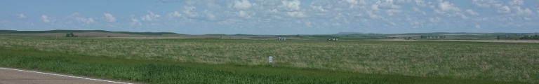
Eventually, the canyon did end at the tourism outskirts of Spearfish. Scattered over an assortment of bald hills were various wooden resorts with a golf course or two added for good measure. I went through the town proper yet again and turned north. Quickly the mountain forests were left behind and grassland returned. It felt more like a mountain plateau than prairie, though.
Just before Belle Fourche: a left turn with a petrol stop worked in and onwards into the west. The landscape became even more pronounced mountain plateau, sometimes even mountain valley. It was high time to change into a state better known for this kind of thing: Wyoming.
Right after the border, a bunch of signs explained the rules of the new state. Among them: ‘All watercraft must be inspected.’ Unfortunately, it neglected to explain where and when and by whom and what for.
A nice feature of Wyoming is proper town signs listing the population and elevation. Thus I can tell you that Aladdin, the next village, had a population of fifteen (plus, hopefully, a genie) and an elevation of 3,740 feet. It mostly consisted of a country store by the road, so the numbers surely didn’t look that far off.
A historic marker by the road explained details of the Custer Expedition of 1874 which in these parts substitutes for the Lewis and Clark Expedition. Its purpose was to charter the Black Hills and find a good route west. It did prompt a gold rush against wishes of and treaties made with the Sioux which resulted in the Great Sioux War of 1876, best know for the Battle of the Little Bighorn and Custer’s demise.
Crossing another mountain on a rather windy road, I came into a canyon valley with red rock walls on either side. The walls weren’t all that tall, perhaps a hundred feet. At the centre of the valley was Alva, population fifty, after which the road left the canyon by way of a side valley.
Atop the ensuing mountain ridge a long rock appeared in the far distance. The frustrum of a giant cone, it stuck out of an otherwise rather flat landscape. Little surprise, then, that the settlers called it Devils Tower while it is sacred ground to the earlier locals who would rather call it Bears Lodge.
It disappeared again as the road dived for another canyon and Hulett. It started with an ugly brown building complex before turning into a pretty western-styled centre by the Belle Fourche River. Someone has gotten sick of all the mowing and decided to burn his lawn instead.
A few miles on and there finally is the Devils Tower National Monument. The tower is a 386 metre tall igneous intrusion (to steal a phrase from Wikipedia) rising up to 1559 metres. It is formed from vertical columns that bend sideways towards the bottom and really look really rather spectacular.
A two kilometre trail surrounds wanders through the pine forest once around the rock, starting at the visitor centre to the west and allowing a look at all sides. If you insist, you can also climb up, but that requires registration and some gear (the former being the more important, judging by the many signs). The native tribes would you rather not do that, though, so I dutifully refrained.
What really surprised me, though—perhaps more so than the stunning beauty of the place—, was that I had never heard of it before and really only came here after accidentally reading the Wikipedia article on the Black Hills. Why it isn’t on top of everyone’s must-see list of America is beyond me. But then, there already was too many visitors, so maybe this is for the better.
I eventually left again and headed towards a town called Sundance. To get there, the road had to climb up onto a ridge where it stayed for a while before evading into a valley running alongside the ridge. Shortly before Sundance and its Interstate junctions, a sign appeared suggesting one should perhaps consider visiting something called Wall Drug.
Sundance itself was a small mountain town with a rather grand John Deere dealership. John Deere is a rather omnipresent manufacturer of those oversized green contraptions so beloved by America’s farmers.
Beyond, a short-cut road towards Newcastle ran along a rather wide mountain plateau. There were hills on both sides covered with pine forest, but down here there was mostly grass. It was even flat enough to let the road run straight for a while. Back on the US highway, now heading east again, an ordeal of road works ensued. Both Wyoming and South Dakota, to which the road returned after a while, decided that the road needed work. As the latter was also widening the road in a windy mountain section needing ample of earthwork, I had to endure lengthy stops but was rewarded by close-ups of the impressive machinery employed for the task.
South of the mountain range, the landscape had become visibly drier: the trees were smaller, the grass more yellow and completely gone at times. Only once the road started climbing into the mountains again did proper pine trees slowly reappeared.
A few of the cars in the convoy the roadworks had started decided to pay Jewel Cave National Monument a visit. That sounded suspiciously like guided tours only and also like a name made up with tourism specifically in mind. Turns out Jewel Cave is the third longest cave in the world with more than 150 miles of passageways which clearly I didn’t have the time for.
Instead, I came through Fourmile, a western town museum complete with palisade fence and, roughly four miles later, to Custer City, the first European town established in the Black Hills and, by the looks of it, not much changed since. The entrance from the west had a very stereotypically western feel to it: on the side of a green grassland valley were large free-standing round-headed rocks with trees on top into whose shadows ducked wooden buildings. Further along, the city did develop a bit of a modern quarter, culminating in the Flintstones Camp Ground and Theme Park.
Traffic thickened as the road homed in on the Black Hill’s attraction to rule them all: Mount Rushmore. Factoid number one: the otherwise fabulous annual National Park Pass is not accepted. Factoid number two: come here in the morning. By my arrival time at around three, the sun had moved westward enough to have Roosevelt all in shadows.
Heads of three more presidents on display: Washington, Jefferson (the one that looks suspiciously like Odo from Deep Space Nine), and Lincoln. Not only the visitor centre below looked brand new. The heads themselves had been cleaned up by the Germans only in 2005 (the colloquial German word here would be abkärchern; Kärcher indeed did the work).
As to whether seeing Mount Rushmore was worth the trip, I was undecided. Much like with Grand Canyon the year before, the things you have seen a thousand times on television rarely overwhelm. But even though it is not quite the Argonath, the carvings are impressive.
Having endured American vacationers and their inbred fear of bends, turns, and descents for long enough, I decided to head east out of the mountains as quickly as possible. First, though, there was Keystone, population 300, hotels rooms roughly three million. Yet another western-style main street was bordered on either side with a chain of hotels of all known brands and then some. Leaving town, there even was the Big Thunder Gold Mine.
The road east left through the narrow valley of Battle Creek before climbing across hills and reaching the grassland. Here, a divided highway was waiting to take me south quickly. First, the hills and their pine forest occasionally reached almost to the highway, but soon the landscape became more and more empty. After crossing the Cheyenne River, civilization ceased completely. It came to a craven revival at Oelrichs, a dusty and slightly shabby looking prairie town out nowhere.
The State Line Club and Casino marked the end of South Dakota and a new beginning, namely Nebraska. Not far any more to Chadron. But it had a surprise: fully booked hotels. So, onwards.
The road started to climb quite a bit through a stony valley, came up onto a flat section. But soon enough, the landscape decided it wanted to be hilly again. Perhaps fifteen miles outside of Alliance, grain farming started. Outside Alliance I stumbled upon a rather busy railway line. Coal trains were parked everywhere. Apparently, the railway line and all these coal trains were coming from the Powder River Basin some 250 miles to the north-east.
In Alliance, the hotel search didn’t result in anything either, but this time I was smart enough to ask the hotel clerk to phone ahead. I managed to reserve the last room in a hotel in Scottsbluff, another hour away to the south-west.
To get there, road and rail had to climb constantly for perhaps twenty miles. This was particularly impressive for the railway line particularly given the heavy coal trains. The landscape became drier and more brown and irrigation started to appear. Off to the far south, a rock cliff line appeared along the horizon, perhaps marking the imminent start of Colorado. Scottsbluff wasn’t far, any more.