One
Virginia
The District of Columbia, outside of the US often simply referred to as Washington, originally was a one hundred square mile diamond-shaped area located where the Potomac and Anacostia rivers meet. Later, Virginia wanted its land south-west of the Potomac back and so there is only a little shy of seventy square miles left.
Little surprise, then, that neither of the two airports that have Washington in their name actually is in the District of Columbia. Washington National airport just across the river in the part that was returned to Virginia is too small for international flights, so Washington Dulles International Airport was conceived twenty miles west of the city.
Nearby, in an industrial area nominally part of Sterling, I begin my trip on a Wednesday morning in early October. It is still early enough to experience the morning rush, which is still felt dearly this far out. Along the busy highway, my plan is to swing west around the busy parts before turning south towards North Carolina.
Three roundabouts later, traffic finally dies down as the road enters into more rural Virginia. It narrows and starts to wind along green hills where autumn has started already. This isn’t fabled Indian Summer yet—for that I am a few weeks too early—but there is enough colour to hint at the spectacle to come.
It also is still quite warm, daytime highs promised to almost reach thirty Celsius degrees. The sky is overcast, though, and the sun hidden away behind hazy clouds.
Behind a few more hills lurks Middletown, easily mistaken for an English country town: pretty Victorian brick buildings hidden in plush gardens, pubs and shops huddled by the road. There is even people about on foot.
I leave the highway in favour of even narrower country lanes. The landscape takes to a very clean, almost Swiss air. The odd forest interrupts well-mowed meadows beset with shrubberies looking almost as if they were trimmed into shape. This goes on for quite some time. But eventually the hills end and the road takes a more straight approach in order to reach Culpeper.
It features a quite pronounced centre with plenty of businesses in handsome red brick buildings. But I shun it in favour of a strip mall since I need to stock up on my usual road trip supplies: water and carrots. I also need new batteries for the dictaphone which have gone dead since I last used it half a year ago.
After the shopping spree, I turn south again following a railway line. It isn’t used by a train as such but by a pick-up truck serving, presumably, as a maintenance vehicle. There is lots of wildlife about. A bunch of black birds that may or may not be wild turkey are sitting by the road, scurrying away from traffic, while a raven nearby doesn’t care. A squirrel or perhaps chipmunk races across. Apart from the current wildlife, the road is plastered with specimens of the recently deceased variety. Either the wildlife here is more stupid then in Europe or there is just more of it.
Since Culpeper, the landscape has lost its Swiss approach and turned wild and messy. The grassland is more brown and beset with small bushes and even trees everywhere. The forests seem more Sherwood and less Windsor, surrounding the road with a tunnel of leafs.
The road crosses a river with a dam and an old mill on a large concrete bridge. Right after, there is a shining white wooden church that looks a lot like a small-scale wood version of Notre Dame, complete with spires and Gothic arches. Neither
The city of Orange is next where large white columns are extremely popular. Pretty much every single house has one, not just the bank or courthouse. Contrary, Charlottesville, a few miles on and a lot bigger, doesn’t seem to have a centre at all. It does mark the beginning of a very busy stretch of road, though. I bravely follow it all the way to Keene, a point on the map more than something recognisable in the real world.
I happily turn into a side road of the most narrow and unsteady variety. It leads to a village called Esmont (or so the map says). Its largest building, a proud red brick box, has the word ‘bank’ out front. There is a few more houses half-hidden in large green gardens and breathes a very relaxed air. Beyond is a main highway again and the start of the mountains, announced by a big yellow curve warning sign complete with grave blinkenlights.
Thus warned, the road crosses a mountain and joins with a fast divided highway along the valley floor. It bypasses Lovingston, which looks lovely from afar, but not lovely enough to stop. The valley quickly deteriorates into rolling, well-settled hills, a clear indication to turn off the main road. A side road presents the opportunity to climb up into the Blue Ridge, looming in the distance. It is closed for trucks, always a good sign.
But first, it enters into a wide, flat-bottomed valley. It passes by a dedicated apple store in a large barn. As the mountains draw nearer, the valley narrows and the road starts twisting to follow it. But eventually a row of warning signs appears and the climb begins.
The map suggests an attraction named Crabtree Falls a little off the road, but the entrance to it whizzes by among the turns and, guessing that it really only is a waterfall, I can’t be bothered to turn around. Instead, I pass through Montebello, marked as a village on the map but really only a store in the centre of a short grassy valley interrupting the endless forest.
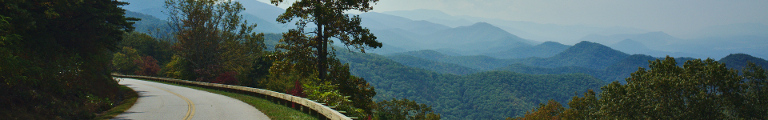
The road climbs on, reaching a mountain pass where it meets the Blue Ridge Parkway. There is no intersection, but the road dives through under the parkway instead with a freeway-style access ramp connecting the two.
This is the theme for the parkway: a more than four-hundred and fifty mile long road along the top of the Blue Ridge with not a single intersection. While not a national park, the road and land along it are managed by the National Park people which means that all facilities are closed today, thanks to the 2013 US Government Shutdown. Luckily, the road itself is open.
According to Wikipedia, it always has been the most popular item in the National Park system. I can’t quite see why. For the most part, the road runs through dense forests with absolutely no distraction. Every now and then it sneaks out and affords sweeping views over the Appalachian Mountains to the west or a series of mountain ranges to the east. It gets old real quick. And this is only mile 90 or so.
Stopping at one of the vista points, I collect a stowaway, a large bug clinging to the driver’s side window with its antennas flapping madly in the wind. It distracts me for a while, but I shed it at a parking lot a few dozen miles on, as it threatens to crawl inside. Also, I had to get my emergency cookies from the boot, as the food situation along the parkway looks somewhat grim.
As soon as I do that, though, the Peeks of Otter area appears which not only as a lake and a peak that doesn’t look like an otter at all, but also a lodge with a restaurant that is actually open. But now I am stuffed with carrots and Oreos and have to refuse.
Instead I roll on. Slowly, the mountains on the right disappear and those on the left move away in the distance. The parkway swings around the populated area of Roanoke marked by a short interval of rolling hills before climbing up agaib. This new range is a whole lot rockier, with giant boulders improving the view.
At Bent Mountain—yet another place only existing on the map—I finally give up. A regular road is running almost parallel but in the valley. It not only is faster, not being speed-limited to 45, but also more interesting what with signs of human life by its sides.
These signs eventually cumulate into Floyd, VA. Starting out well with a rehab centre, it climaxes with a little red-brick centre by the highway intersection and a large metal water tower on the top of a nearby hill.
After so much excitement, the road quickly hides in forests again. It passes under the parkway and the starts a long, hairpin descent. Ten minutes later, having been interrupted a few short times by settlements, it still goes down. Eventually, it starts to have to go up a bit before being able to go down even more.
It only gives up this at Stuart, a town on the side of a hill. The centre is far up top. Several roads go down the side, intersecting at odd angles and creating strange, intertwined junctions.
A couple of miles further south through heavily settled hills to the state line.