Tuesday, June 4th
I Know They’re Out There
In 1879, the Texas decided it needed a new capitol. Being short of money but rich of empty land, the state decided to trade the latter for the former. The Farwell brothers of Chicago, Illinois agreed to build the new capitol with its whopping three million dollar price tag. In exchange, they got three million acres, or twelve thousand square kilometres, of ranch land along the New Mexico border thus creating the XIT ranch. But they got shortchanged. Cattle prices fell and it is somewhat hard to effectively protect a ranch that size. By 1912 the main business had changed from selling cattle to selling land.
Leaving Dalhart on a warm, sunny morning, heading south-west, I cross through the lands of this once famous range. A sign at the city’s exit warns that the next services are available in seventy-five miles. For the first couple of miles, the land is now used for grain farming after someone figured out an effective way to water these dry lands. Soon, though, signs of civilization become sparse. Middle Water, a marked spot on the map, consists of a sign by the road announcing its name, a few trees by the road and a parking lot with a utilities shed.
The border with New Mexico is the next, somewhat overrated event. It mostly means that we jump an hour back again into Mountain Time. My cell phone provider gets all confused by the new state and promptly sends me a text message listing the prices for services in EU countries.
Nara Vista is the first village in New Mexico. It is a formidable collection of old, rusting automobiles with a couple of wind-swept buildings added as an afterthought. Only the weighing station, mandatory at every state border, is all new and fancy looking.
Logan, twenty minutes on, is the similar but a little newer. The cars aren’t so rusty yet. And, being a crossroads, it has a few more businesses to boot. It also features a impressive bridge over the even more impressive gorge of the Canadian River before reaching the promised crossroads allowing me to turn into a southerly direction.
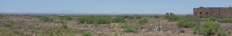
This is still rather deserted, probably officially counting as steppe. Every once in a while, there is a collection of trees and green with a house in its centre. Whether these spots are artificial or rather the houses have conveniently been placed where there was some green already, is hard to tell. Definitely artificial is the intersection with the Interstate, all petrol stations and towing businesses.
Straight ahead in the distance looms a mountain range or rather a fifty metre tall step in the otherwise flat country named Caprock. It’s edge is home to dozens of wind power stations. Up, the ground looks a little less dry and serves as farmland again. A recently abandoned farm, complete with main house and barn and additional outbuildings, all in quite good shape, tells the tale of the recent troubles.
Grady and, later, Broadview are tidy little farming towns with plenty of green. Somewhere in a field out nowhere stands a huge, cathedral-like grey buidling perhaps two hundred metres set back from the road. It has a large, three-storey panorama window at its front and looks suspiciously like the headquarter of some mad cult.
The city of Clovis, population not quite forty thousand, marks the return to the realities of American civilization. For miles the road is lined by ugly commercial shoe boxes providing all kinds of things. One store rather optimistically sells boats. The map is showing the next permanent body of water to be a salt lake twenty miles away. A few residential buildings, shoe boxes, too, bravely cling to a few blocks at the end of town.
Ten miles or so out, the huge Greyhound Football stadium, complete with convention centre, points out that Portales, another ten miles on, is home to the East New Mexico University and its college football team. The town itself, after starting off with a bunch of factories, turns out to be rather nice. Downtown is a collection of stylish old brick buildings, some in yellow plaster, some untreated red brick. I have time to enjoy it, since major roadworks slow down traffic: a yellow-brick curiously is surrounded by two banks and followed by a secondary church.
The town’s exit (or rather, the entrance the other way) is marked with a statue of an old F11 fighter plane, presumably in connection to the Air Force base north of town.
Urbanity sprawls out of town for about ten miles before giving way to farmland and eventually wilderness. Twenty miles to Elida, an intersection with a school, a church, some stores and a post office. The same goes for Keena, only that residences are strewn all over the place in a rather messy arrangement. A railroad is running alongside the road. All its sidings are abused to park grain hoppers and ready for the big harvest.
The reason to park them here is the climate: it is really quite dry. The landscape is flat and systematically boring. An oil field is about the only distraction for a good hour’s drive.
Eventually, a lone mountain appears out of a distant haze and marks the approach back into civilization. For this we have to climb down into a huge red valley. We cross the Pecos River which actually carries some vague memory of water. First sign of human life is a factory next to a salt marsh and then, later on, large yards with hundreds of cars parked.
After the happy appearance of ‘Thumbleweed!’ I finally arrive at world famous Rosswell, New Mexico. I quickly stop at a Walmart for its restrooms and ponder the marvel of keeping such a giant building freezing cold in thirty-five Celsius degrees. Even in America, they must accumulate an enormous power bill.
Roswell itself is disappointingly normal. There is maybe two or three alien statues, the largest obviously at a used cars dealership. But other than that, the city features a relatively handsome downtown of large nineteen century brick buildings, most prominently the courthouse in a small green park.
To go with the stereotype, a large mobile home factory outlet store features just outside the city on the way back into the desert. Ten miles out and thoroughly lonely, someone is selling five acre homes on a hill by the road. The thermometer finally reaches a hundred degrees on the Fahrenheit scale.
It turns hilly, affording the road a few bends before entering the green and lush valley of the Rio Hondo near aptly named Riverside. While the walls of the valley are still grey and rocky and deserted, the valley floor amasses in trees and bushes and grass. It really is quite an amazing thing. And it goes on and on.
Various signs and names point out that the village of Lincoln is the home of Billy the Kid. Subsequently, Lincoln is now a historic district. It is nicely preserved and features a bunch of tourists enjoying the old, spanish-style buildings with their white-washed walls and small windows.
The green valley eventually runs out as the road climbs up to a small pass. On the other side lies the village of Capitan, home to the Smokey Bear Historical Park. Why the mascot of a campaign against wild fires first started in 1944 deserves a park, I don’t know. As always, I also don’t stop to find out.
Outside, I can hear a sound that may or may not be that of rattle snakes. Probably safest to stay in the car, just to be sure.
A sign announces something called the ‘indian divide’ of which I can’t find anything. But we are crossing some form of pass and dive down into a wide valley. Passing by the Vale del Sole Golf Course the road arrives in the fairly wealthy looking town of Carrizozo. The wealth may or may not be related to the nearby White Sands Missile Range, announced merely by a sign suggesting the possibility of road closures due to missile firing. The range is the sorry sight of the world’s first nuclear bomb explosion on July 16th, 1945.
But first, we have to cross the Valley of the Fires, a three mile wide old flow of lava, then climb a mountain, cross another valley and another mountain before running along the northern boundary of the missile range without incident. One more mountain range leads to a wide, endless valley with red soil. A dust devil, a small whirlwind sandstorm twists alongside the road, making for curious entertainment. Further on, running along the valley, more than a dozen of these things appear in the distance.
Bingham, one of the sparse name spots on the map, turns out to be exactly to residencies. One also features a rock shop and the other a huge billboard.
Finally, the road dives even further down into the fertile valley of the Rio Grande. The sight of actual water is quite strange after a day in the desert. Above the mountains to the west, the evening clouds are starting to brew. I take the Interstate north for a quick hop to Socorro, serving as my quarters for the night. I much rather would have stayed in the beautifully named city of Truth or Consequences, but it lies a good hour to the south.