Wednesday, June 5th
A Science
It has gotten rather late when I finally start up the engine and roll out of Socorro. Sitting between the Rio Grande and a huge mountain to the west, the roots of the city go back to when the Spaniards first came through the area in the late sixteenth century. The city has a little downtown around a rectangular park lined with old buildings. Like all cities of its size, its main function seems to provide services for the people of the outlying villages and farms.
I keep going west, but thanks to that big mountain, the road has to swing south first. It climbs up onto a plateau, maybe two miles wide and with no end in sight ahead. There are few trees, but thorny bushes and spiky things dominate the view, apart from lots of yellow grass.
Despite first appearances, the valley does come to an end or rather, a step appears and the road climbs into a similar valley one level up. The step is the village of Magdalena, home to a large red concrete structure with a blue roof, presumably a school building. There is a few motels, even a hotel apart from residencies and businesses and stray dogs.
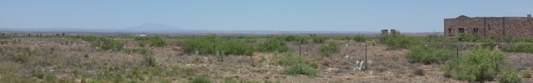
This new valley isn't straight but instead the road keeps climbing. It cuts right through a hill instead of just going fifty metres sideways and avoiding it neatly. Eventually and surprisingly, we end up at a new plateau full of dark green trees. But it is over soon enough and the road falls down into a huge basin, the Plains of San Agustin, home of the Karl G. Jansky Very Large Array or just VLA for short. Opened in 1980, the VLA is a radio astronomy observatory consisting of twenty-seven radio telescopes and one spare. These telescopes are essentially twenty-five meter dish antennas each weighing a bit over two hundred tons. As if that isn’t cool enough, the observatory has its very own railroad to move these monsters around, since they can be arranged in different formations, varying from sitting very close together to being shifted out along wye shaped arms allowing for a maximum base line of thirty-six kilometres.
Besides a small visitor centre with plenty of displays and some videos on a loop, the operators have kindly designed a short self-guided tour around the facilities including a close look at one of the antennas. It is packed with fun facts to know and tell, such as that the actual receivers are cooled down to four Kelvin in order to avoid interference.
I spend an hour happily rummaging around the area. It isn’t all that hot up here at 2,200 metres but it really is rather dry. Which is the whole point as it avoids interference from humidity in the air. The surrounding mountains not only block rain but also radio interference from civilization. Various signs remind visitors to turn off their cellphones and whatnot, providing the simile that if you put your active phone on the moon, it would still be the brightest thing visible.
Eventually, I drive on. It takes some time to cross the basin, but at its end the town of Datil is waiting where the trees are back. It is mostly just a petrol station and a post office and quickly we are back in the dry endlessness. A sign warns of elk; these beasts seem to be everywhere. Another sign points and says ‘Library,’ presumably a settlement and not an actual library.
We are crossing straight through yet another flat plains with rocky mountains in the north and flat-top mountains far far in the south. Beyond, some more mountains beckon. They contain a sign pointing out the continental divide at 7,796 feet (or 2376 metres) before leading down to the Pie Town with a firestation and a collection of old water pump wind mills. Road signs warn of a congested area and roadside businesses. I presume they are meant ironically, as there are about three of them and no other cars on the road. But then, it is noon and not afternoon rush hour.
Yet another flat plateau thereafter, this one contain a heliport in the middle of nowhere.
Quemada has houses all over the place and a small town centre with various services and an ATM in a shed, plus gift stores and a café. Red Hill, in contrast, is exactly one building on top of a small hill that isn’t red at all.
After running straight for quite some time, the road suddenly enters wide curves, crosses into Arizona, and returns to running straight again. Maybe they missed the agreed upon crossing point when building the road.
A little further into Arizona, we climb down into a wide and green valley again and arrive at Springerville, yet another messy town with buildings all over the place. It also has two huge modern churches. After getting lost a bit, I finally find my way into the neighbouring town of Eagar only to get lost yet again. Eagar seems more affluent, but maybe that is just the effect of the large trees lining the road. There is yet more big modern churches before I find the way out and up into a yellow, grass plateau.
There are forest-covered mountains to the left beyond a deep river valley that contain various cottages. The road keeps climbing and eventually also enters a forest. The landscape turns into a regular mountain area with forests and grassy bits complete with ‘Snow Blow Area’ warning signs and we enter Fort Apache Indian Reservation. The Sunrise Ski Area is somewhere to the left whereas our road dives down again and even runs by an actual lake, which is a bit of a surprise after all the desert.
McNary is a village hidden in the forest with the buildings peaking shyly through the leaves. It turns out to be a local custom as the rather large city of Pinetop/Lakeside does the same. It starts out normal enough with resorts and cottages hidden behind trees but continues with all the usual amenities of an American town peaking through as well. It does improve the look quite a bit, even though the fact that the town is effectively just one long street makes the effect wear off eventually and just makes you hope it would end soon. But it doesn’t as Snow Low follows right away in a similar fashion though with more clearings and less trees.
The county has invested in several speed cameras or ‘photo enforcement zones’ as it is called to avoid European language. These installations consist of six or seven devices by the road and make it all look rather high tech.
The road also is rather annoyingly busy and continues to be so beyond Snow Low. Normally, things get somewhat hectic around cities but quiet down quickly. But not here. We are still travelling through tree-beset mountains forcing the road to curve a lot. Each bend is mastered very slowly and carefully by my American travel companions.
We reach another town hidden in the forests, Overgaard. This one has a bunch of western-style wood buildings early on and then just keeps going on and on and on.
Traffic isn’t dying down after either. Instead, the road turns into a divided highway on its way to Payson which, you guessed it, is a city hidden in the forest. It is quite a bit drier here, though, and the trees are smaller. Still plenty of them.
After leaving Payson, the road dives down into the valley of East Verde River only to climb up again immediately after reaching the bottom. It reaches Pine (village in the forest), goes up, down, Strawberry (rather tiny village in the forest), and then up, up, up. Once all the way up, I turn off to the left in west again. The new road lingers on a bit before going down six hundred metres or so in one fell swoop.
Is target is the lovely green valley inhabited by Camp Verde but, more importantly, an intersection with the Interstate taking me to today’s destination Flagstaff. I would have expected it to just keep travelling along the valley, but instead it crosses yet another mountain range. So, I expect it to dive down into a valley just before Flagstaff, but it doesn’t do that either. Turns out the city sits smack in the mountains at two thousand metres altitude.
Being eighty miles south of Grand Canyon and at the intersection of two Interstates, the city is quite busy. Being a bit late, it is past six already, I am a bit afraid to have to look endlessly for a spare room (full motels being a bit of an issue on this trip so far), but I needn’t have worried. The motels are huge and prepared. They are also far away from the city centre, so I prepare myself for a coke-meal having to drive to a restaurant.
But as luck will have it, there is a proper restaurant in walking distance. Better yet, they feature an extensive beer menu. Limiting my choice to ‘something local’ doesn’t help much either. It seems there is quite a few smaller breweries in the area. I decide to splurge and have steak with some fine local IPA.